
Poster 1000x717 pixlar
Transformation of a chartbook - Piri Reis’ sailing handbook reused for a survey of Mediterranean vegetation and architecture.
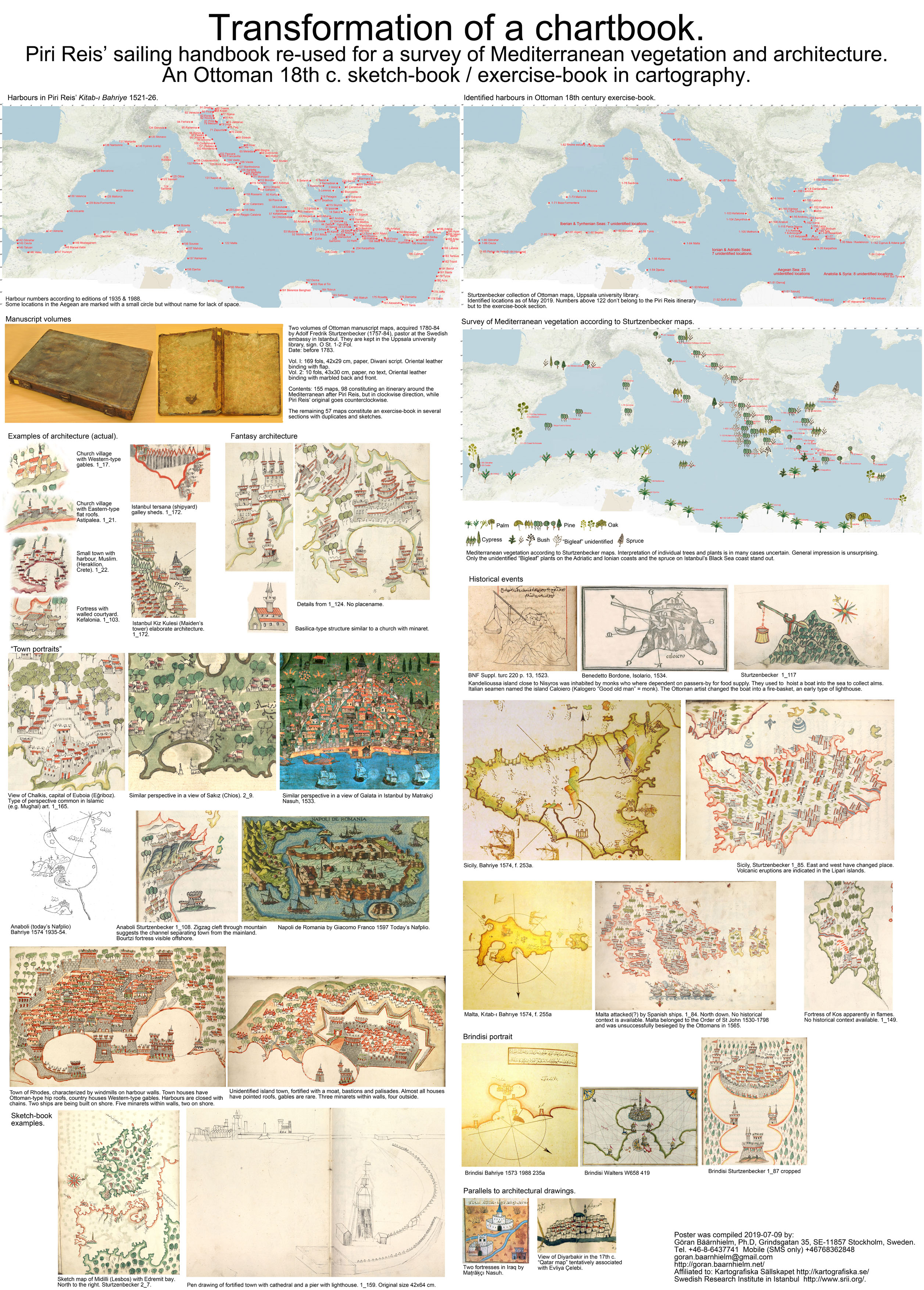
Uppsala University Library keeps a 2-volume collection of Ottoman manuscript maps acquired in Istanbul during 1780-1784 by Adolf Fredrik Sturtzenbecker (1757-1784) who was Pastor at the Swedish embassy in Istanbul.
Part of it has recently been identified as a version of naval captain Piri Reis’ famous sailing handbook of the Mediterranean, "Kitab-i Bahriye," from 1521-26. The content of this version is basically the same, but the sequence of the maps is different. The itinerary, covering 70% of the first volume, goes clockwise around the Mediterranean, while Piri Reis’ original goes counter-clockwise. The character of naval chart-book has been abandoned. Only a small number of maritime symbols are retained, and many maps have been redrawn beyond recognition. Instead, the emphasis is on a diversified representation of vegetation, and of architecture, which is often imaginative and sometimes verging towards the fantastic.
Most itinerary maps are provided with captions in Ottoman Turkish, which the author of these lines cannot read. Translation assistance has been limited, so 47 of the 98 maps remain unidentified, 51 maps having been identified with varying degree of certainty. This, however, is sufficient to decide the clockwise direction of the itinerary.
After the itinerary, there follow six sets of maps of varied content, covering the remaining 30% of volume 1 and all 10 maps of volume 2. These are largely duplicates, but also a set of islands with fancy architecture. Possibly these maps do not represent any existing locality, but are rather examples of indulgence in the joy of imaginative map-drawing. Another set includes three views of fortified insular harbour towns, and a central perspective view of a type used by Ottoman mathematician-artist Matrakçi Nasuh (1480-1564). He also provides patterns for the fortress and palace architecture commonly used in these maps. Surprising parallels are also found in the so-called “Qatar Map of the Tigris and Euphrates” associated with the name of Evliya Çelebi (1611-1682).
Occasionally maps seem to illustrate a historic event, e.g. Malta with Spanish ships approaching, or the island of Kos with a burning fortress. But the general impression of the maps is dominated by the vegetation. Some 15 different tree-types can be distinguished, the most obvious being the various palm species defining North Africa. But in other cases even trained botanists have had difficulties in identification.
Conclusion: The very different structure of the itinerary, the focus on land mapping with an emphasis on architecture and vegetation, and in addition the many variant and duplicate maps and sketches must define this not as a true version of the sailing handbook by Piri Reis but rather as an exercise-book in map-drawing inspired by his maps. If it has any connection with the courses in cartography at the Golden Horn Naval Engineering School, going back to 1773, must remain a matter for conjecture. Perhaps a full translation of the Turkish captions may shed light upon the origin and purpose of this map collection.
Göran Bäärnhielm
http://www.alvin-portal.org/alvin/view.jsf?pid=alvin-record%3A55710&dswid=-8371
http://www.alvin-portal.org/alvin/view.jsf?pid=alvin-record%3A55716&dswid=9516