 |
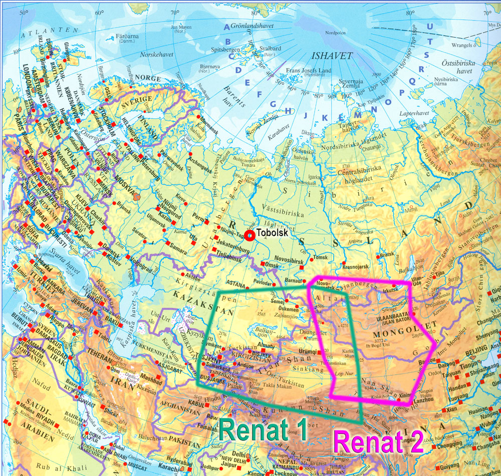
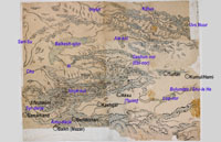
1. Overview Eurasia with Renat maps |
|
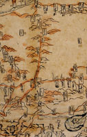
2. Renat 1, norr uppåt, dvs upp och ner
Renat 1, north on top, i.e. upside down |
 |
3. Renat 1 textad |
 |
4. Renat 1, utsnitt av sydvästra hörnet med Samarkand och Badakshan
Renat 1, detail of Southwest corner with Samarcand & Badakshan. South on top |
 |
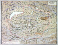
5. Renat 2, norr uppåt dvs upp och ner
Renat 2, north on top, i.e. upside down. |
 |
6. Renat 2 textad |
 |
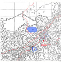
7. Renat 2, detalj kring Kumul (Hami), rättvänd dvs söder uppåt
Renat 2, detail around Kumul (Hami), south on top |
 |
8. Renat 2, detalj kring Dunhuang
Renat 2, detail around Dunhuang |
 |
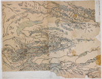
9. Renats egen (?) avritning av 1
Renat's own(?) copy of 1. |
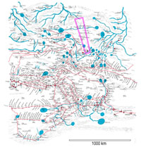 |
10. Renat-2-kartans tolkning enligt John Baddeley 1911 med utsnittet nr 18 nedan markerat
Renat 2, interpretation by John Baddeley 1911 |
 |
11. Del av Qianlongkartan 1760 / 1774 i British Library (India Office Records, X/3265/1-10 + 11 (Index) & microfilm IOR Neg 1338) med Renat-2-kartans utsträckning och utsnittet nr 18 nedan.
Part of Qianlong map 1760 / 1774 in the British Library with extent of Renat 2 map |
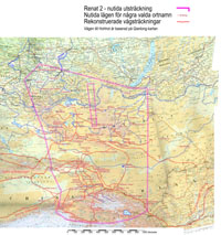 |
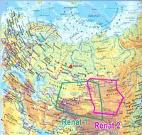
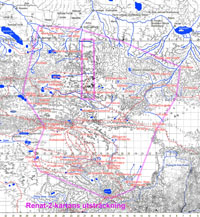
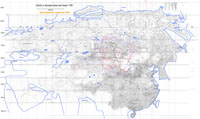
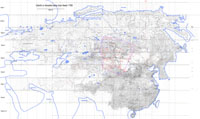
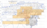
12. Renat-2-kartans belägenhet (underlagskarta Times Atlas) med rekonstruerade vägar |
|
13. Present extent of Renat-2-map with reconstructed roads. Road to Hohhot is based on the 1760 / 1774 Qianlong map |
 |
14. Qianlong map 1760, British Library, India Office Records, overview 51 dpi, 16500 pixels wide. |
 |
14b. Qianlong map 1760, British Library, India Office Records, overview 4000 pixels wide. Red square contains a link to detail of Godoli-Hohhot road map |
 |
15. Qianlong map, extent of copied part of English name index |
 |
16. Qianlong map, Lhasa region, 330 dpi. |
 |
17. Qianlong map, Beijing region. 500 dpi. |
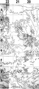 |
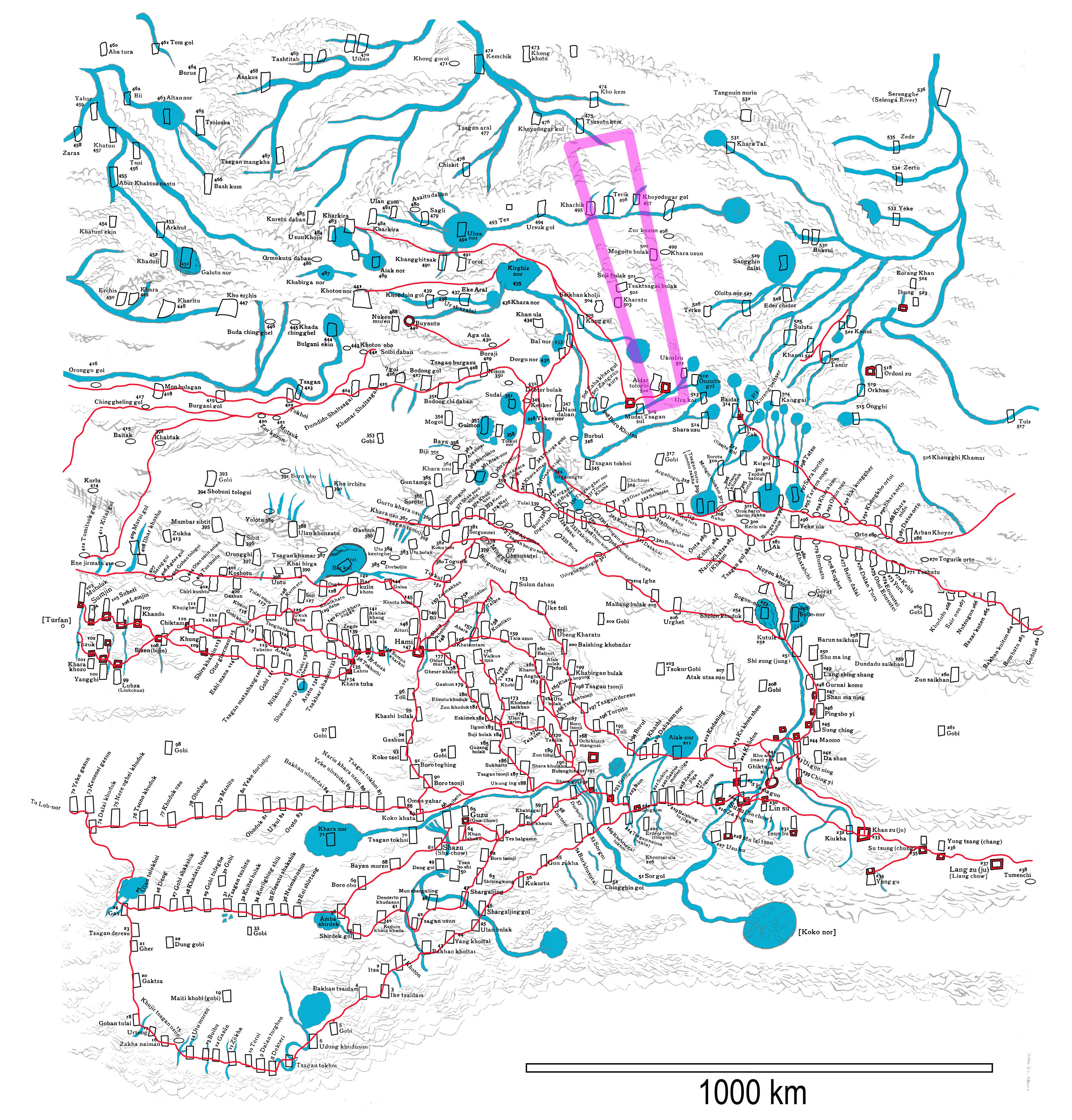
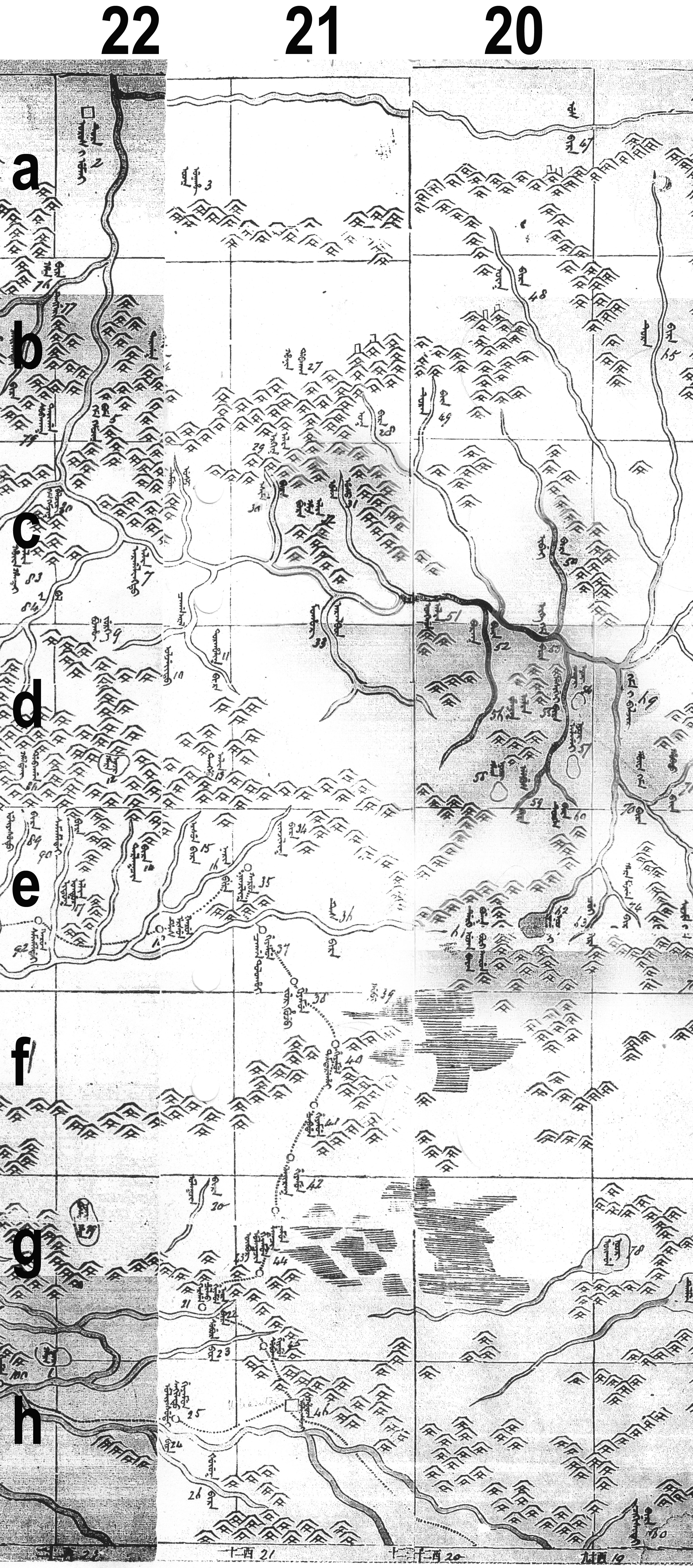
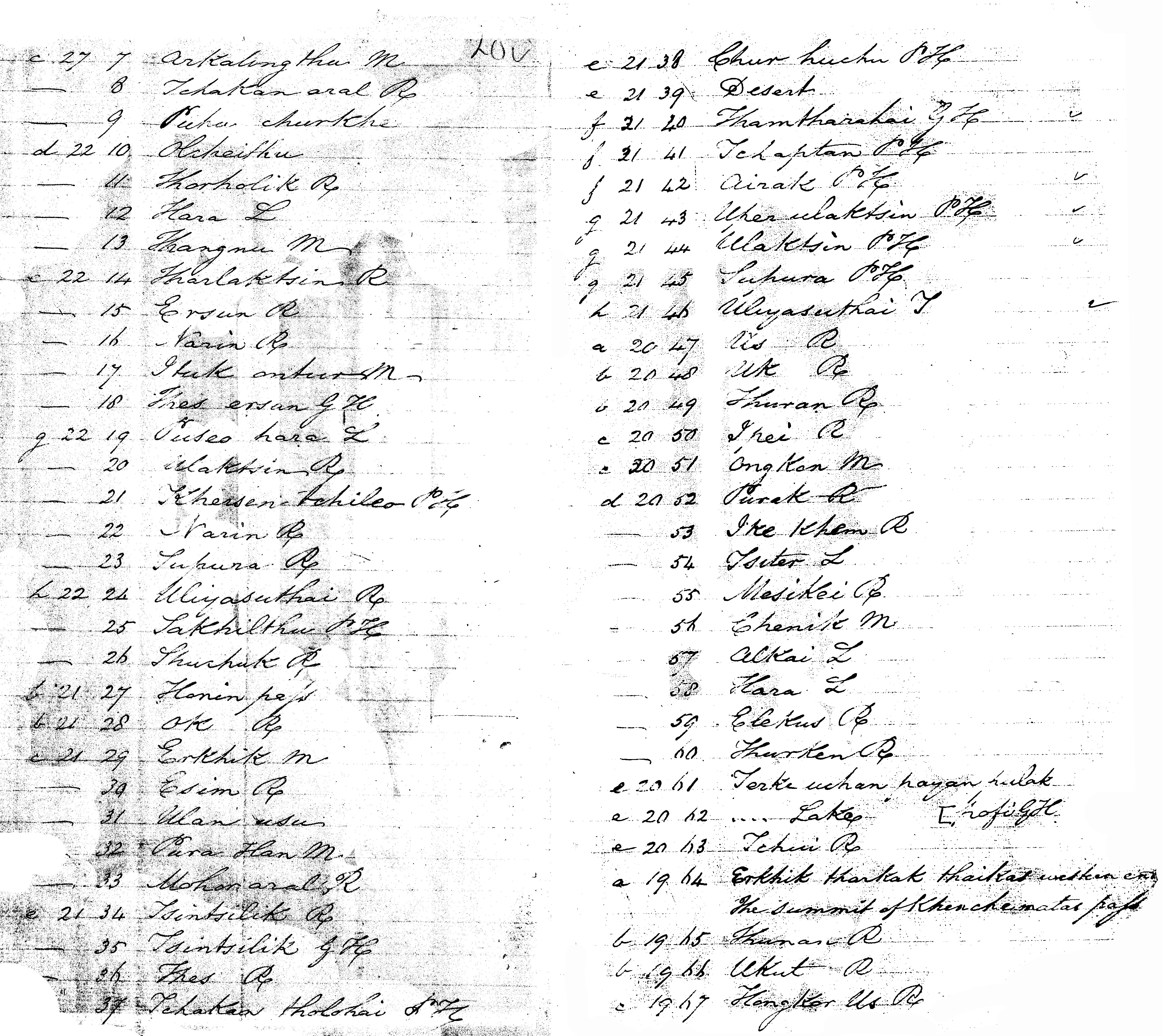
18. Qianlong map, detail around Uliyasuthai (roll 4, square 21 h nr 46, Renat-2-map nr 510 Aldar Tologoi) caravan trade center and de facto capital of Qing Mongolia 1733-1911, today provincial capital Uliastai. |
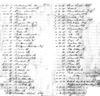 |
19. Qianlong map name index fol. 20v-21r for the above map section (Pdf transcription) with several PH- & GH-sites, probably indicating "Post House" and "Guest House". |
The two manuscript maps brought to Sweden in 1734 by Johan Gustav Renat were the first maps made in Central Asia to arrive in Europe. |
| |
| Renat was an artillery officer who had served under Swedish king Charles XII. After the battle of Poltava 1709 he was brought as a prisoner of war to the town of Tobolsk in Siberia. In 1716 he took part in an expedition to the Irtysh river, looking for gold, was taken prisoner by the Kalmucks (Oirats) of the khanate of Dzungaria and brought to their camp-city Kuldja in the Ili valley, now Yining in the Chinese province of Xinjiang. |
| |
| Dzungaria was a powerful empire based on the control of trade-routes between Russia and China. In the second half of the 17th century it posed a great threat to its neighbours, but was finally destroyed by a Chinese army 1758. |
| |
| Renat won the confidence of the khan Tsevang Rabdan and his successor Galdan Tseren, partly by teaching them the art of casting cannons. He occasionally took part in military battles against the Chinese. |
| |
| 1733 he could return to Sweden and was given the two maps at his departure by the khan Galdan Tseren. |
| |
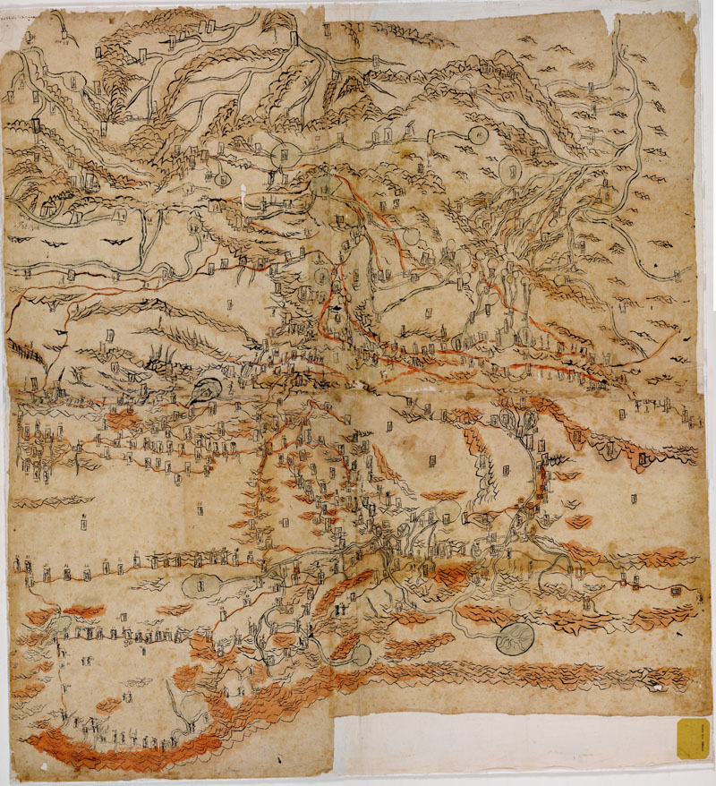
| Map 1 shows the Dzungarian khanate with adjacent areas, from Samarkand in the west to Hami in the east and from southern Taklamakan desert in the south to middle Irtysh in the north. Size is 81x114 cm. Scale varies from about 1:1 600 000 to 1:2 250 000. Orientation is with South on top. The 227 place names are in Kalmuck (Oirat) script. 26 towns are marked, but no roads. The map is considered a genuine early example of Mongolian cartography with some Chinese influence. |
| |
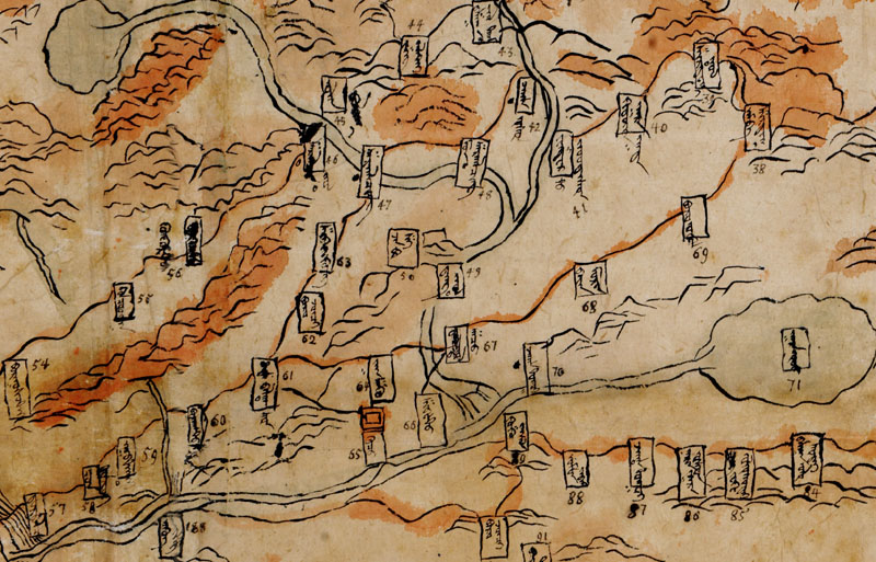
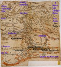
| Map 2 covers an area more to the east, from the Turfan depression in the west to Orkhon and Tula rivers in the east. Size is 110x96 cm. Scale is about 1:2 000 000. Orientation is with South on top. The 536 place names are in Oirat script, in most cases surrounded by a frame. 48 places are marked with a red square or circle, probably denoting fortifications. Several roads are marked in red and provided with the names of relay-stations, often wells. According to Renat this map is copied from a Chinese original, taken from Chinese troops when they attacked Barkul or Turfan, two towns on the contested border between Dzungaria and China. |
| |
| They were donated by Renat to Uppsala University Library and were "rediscovered" in 1879 by Swedish author August Strindberg who notified the Russian scholar Jakob Grot. Renat's own copy of the western map was published in 1888 by the Russian lmperial Geographical Society. The two original maps were published with an analysis by John Baddeley in 1919. He published a list of the place-names in English transcription via Russian from the Kalmuck legends, and identified several places through comparison with maps from 1737-1911, but had to leave many legends unexplained. |
| |
The maps were discussed by Nicholas Poppe (1898-1991), leading specialist in the Mongolian languages, in Imago Mundi 1955. In his conclusion he states:
"This [easternmost] map is particularly valuable, because the most important roads and the relay stations along them are indicated on it. It would be interesting to compare the names of the relay stations with those mentioned in more recent descriptions of travels, because it is possible that the relay stations in Mongolia were the same at the time of modern travellers as in the XVlIlth century. Future research will demonstrate whether it is so." |
| |
| My intention is to do precisely this, to locate place names and compare road networks then and now. This has proven difficult; place names in general and especially those of settlements and road stations are often unspecific - the same name appears in many places - and subject to change, especially in Chinese-controlled Xinjiang. Topographic features, lakes, rivers and mountains, appear to be a safer clue to roads than settlement names. |
| |
| The most fruitful comparison is with a Chinese map of the Qianlong reign, kept in the British Library, based on Jesuit surveys done after the Chinese conquest (some call it genocide) of Dzungaria 1759, believed to have been engraved and printed ca 1760, but dated at 1774 in Walter Simon's and Howard Nelson's catalogue of Manchu books in London, 1977. Most of the Renat 2 place names can be found here. But their modern identifications remain a problem, and there is some confusion in a few cases, e.g. around Dunhuang and Guazhou – Anxi. |
| |
| One definite result from comparison with the Qianlong map is that the Eastern road from Sair usu (267) to Bumbatu (263) and Godoli (262) ends in Hohhot, but I have not been able to locate the stations in between in today's geography. |
| |
| I might use Chinese roadbooks of this area, if any such books exist from the Qianlong period. As I don't read Chinese I must ask for help from colleagues who do. This will have to be a project of cooperation in any case. |
| |
| The maps are kept in the Uppsala University Library. You will find zoomable images at http://art.alvin-portal.org/alvin/view.jsf?file=3943 for Renat 1/A and http://art.alvin-portal.org/alvin/view.jsf?file=3944 for Renat 2/B. |
| |
Literature: John Baddeley, Russia, Mongolia, China, London 1919.
Baddeley pp. 166-196 on the Renat maps
Baddeley pp. 197-216 name lists maps 1-2
A recent study was published in 2011 by
Staffan Rosén: Commentary of the Renat maps, for the Commentary Project of the Center for Central Eurasian Studies' Civilization Archive, Seoul National University (http://www.useoul.edu/), but is no longer available. This center published the Journal of Central Eurasian Studies, which is however not attested later than 2012.
|
| |
| Renat 2 placename list |